![]()
![]()
|
|
|
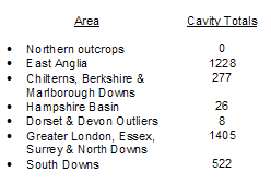
Subsidence Index | Chalk Mining Index | Diagnostic Characteristics | Geographic Occurrence | Investigation & Mitigation | Key Contacts & Expert Advice | Photo Gallery | Essential References & Further Reading | Definitions & Glossary | Data collected on the geographic occurrence of chalk and flint mines over the last 25 years or so has been compiled as part of the national Mining Cavities (non-coal) Database held by Peter Brett Associates (PBA). The most recently published statistics are presented by Edmonds (2008), subdivided into regional outcrop areas of the Chalk and reproduced in the table below:
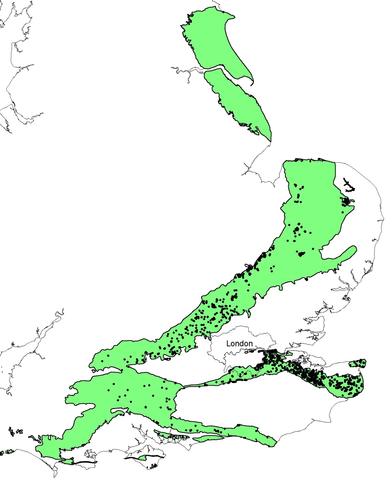
A plan showing the spatial distribution of recorded chalk and flint mines is presented in below.
Schematic plan showing spatial distribution of chalk and flint mine locations across the Chalk outcrop. (Image Source: Peter Brett Associates)
There are no mines recorded in the Chalk of Yorkshire and Lincolnshire. Southwards in East Anglia the chalk mines tend to be located in and around major urban centres such as Norwich. The rural mines are associated with flint extraction such as Grimes Graves, near Thetford and Lingheath, near Brandon. To the southwest, across the Chiltern Hills, the chalk has been mined to provide building Stone (e.g. Totternhoe), to make whiting (e.g. Kintbury), for lime burning (e.g. Hatfield) and for use in the manufacture of bricks, tiles and pottery (e.g. Reading). In the west in Wiltshire and Salisbury Plain almost no mines are known. Hampshire contains small numbers of mines (e.g. Andover) and also Devon (e.g. Beer). Eastwards along the South Downs are concentrations of flint mines associated with ancient hill forts (e.g. Cissbury Ring). South of London, along the Hog’s Back, a few mines are associated with urban centres (e.g. Guildford). Others occur within certain parts of London, especially Bexley, Blackheath, Bromley, Pinner and Woolwich. Large numbers of chalkwells and deneholes are found along the North Downs to the Isle of Thanet, and in Essex (e.g. Grays). Subsidence Index | Chalk Mining Index | Diagnostic Characteristics | Geographic Occurrence | Investigation & Mitigation | Key Contacts & Expert Advice | Photo Gallery | Essential References & Further Reading | Definitions & Glossary | | ||||||||||||||||||||||||||||||||||||||||||||||||||||||||
|